
Ask a class to draw the Silk Road and you may get one long arrow from China to Rome. The arrow is easy to remember, but it can hide the people and places that made exchange possible. A short relay activity helps students see how an object could travel farther than any one of its carriers.
How can goods connect distant communities when most participants travel only part of a network?
Replace the single journey with connected journeys
The Silk Roads were overlapping routes rather than one continuous paved road. UNESCO’s overview of the Silk Roads explains that merchants often traveled particular sections, selling cargo onward at intermediate places. Land and maritime routes changed over time, and exchange moved in several directions. This is the historical idea students will model.
A model simplifies reality. Tell students explicitly that the classroom stations below are fictional market points, not a map of real cities or a reconstruction of ancient prices. The activity tests a relationship between connections and movement. Historical maps and sources are needed afterward to place that relationship in a particular time and region.
Prepare a five-station paper network
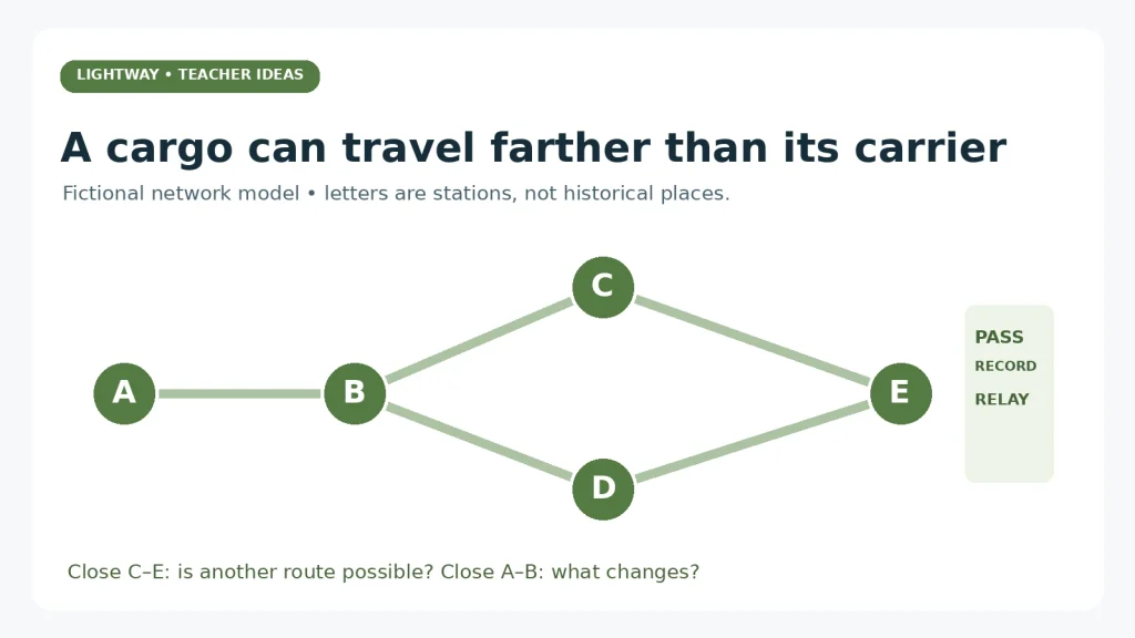
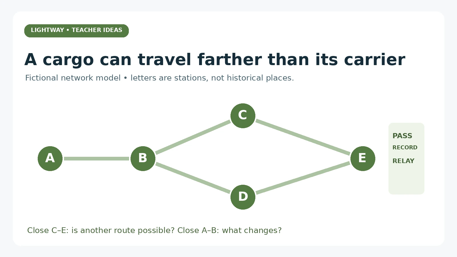
Label five desk groups A, B, C, D, and E. Draw these connections on the board: A–B, B–C, C–E, B–D, and D–E. Give each group one record sheet. Make a single paper “cargo” card and place it at A. No money, competitive bargaining, or food is needed.
The class goal is to move the cargo to E while recording each handoff. Each group can pass it only across a displayed connection. Assign a reader, recorder, and checker, with roles adapted so every student can participate without needing to move around the room. The teacher can carry the card between tables if physical movement is impractical.
Our station: ___
Received from: ___
Sent to: ___
Reason this connection was available: ___
One thing our record does not tell us: ___
Run three short rounds
Round 1: follow the handoffs
Use A–B–C–E. At each station, a different group records receiving and passing the card. Ask students to compare the cargo’s total route with the section handled by each group. The cargo reaches E, but no group has handled every stage.
Then ask, “If we found the cargo at E, would that prove a person from A traveled all the way here?” The answer is no. A final location can support a question about connections, but the specific intermediaries need evidence. This is an important bridge from the model to archaeological reasoning.
Round 2: close one connection
Mark C–E unavailable. Do not call the reason an actual ancient war or disaster; simply define it as a changed condition in the model. Students should find A–B–D–E. Ask what stayed possible and what changed. The network offers an alternative, but only because the displayed connections allow it.
Now close A–B instead. In this particular model, A becomes isolated. Students should explain why “trade always finds another way” is too strong. Alternative routes are possible under some conditions, not guaranteed under all conditions.
Round 3: reverse the direction
Place a different cargo card at E and move it toward A. Ask students to explain why a diagram with arrows in only one direction can be misleading. The exercise does not show that every commodity moved both ways or in equal quantities. It shows that a network can carry different exchanges in different directions.
Model answers to the three rounds
Round 1: the cargo crosses three links, while each station has only its own handoff record. Its arrival does not prove a direct journey by its original producer. Round 2: closing C–E leaves a route through D; closing A–B removes A’s only displayed connection. Round 3: movement can occur in the reverse direction, but the model gives no evidence about actual historical volumes, values, commodities, or travel times.
Return to a dated historical map
After the model, display a map appropriate to the period your class is studying. If your lesson concerns exchange before 500 CE, do not use a map centered on the thirteenth-century Mongol Empire without explaining the change in time. Locate several regions and intermediate centers rather than asking students to memorize one line.
UNESCO’s Chang’an–Tianshan Corridor heritage description documents the importance of settlements, water systems, and other infrastructure along a particular part of the wider network. Use it to ask a concrete question: what support would a journey require between the dots on a map? Water, food, shelter, animals, guides, and local knowledge are not visible in a simple arrow.
The Metropolitan Museum’s Buddhism along the Silk Road exhibition overview also describes connections linking communities and the movement of religious ideas and imagery. Avoid implying that beliefs traveled automatically like sealed cargo. People taught, translated, adapted, accepted, and rejected ideas.
Make the model’s limits part of the learning
Ask groups to name two things their activity leaves out. Useful answers include unequal power, political boundaries, language, negotiation, seasonal travel, labor, insecurity, and the possibility that a cargo would be consumed locally instead of sent onward. None of these can be inferred from how quickly classmates passed a card.
Do not attach invented “authentic” profits or travel times to the exercise. If students later calculate costs, label the numbers as hypothetical unless you have a suitable historical source. Likewise, a blocked classroom link is a reasoning prompt, not evidence that a particular conflict stopped all exchange across Eurasia.
Check understanding with a new diagram
Draw a small network with six unnamed points and two possible routes between the ends. Ask each student to mark one possible cargo route, identify one place where a handoff could occur, and explain what would happen if a chosen link closed. Finish with: “A distant object at a site suggests ___, but does not by itself prove ___.”
A strong response might say that the object suggests a connection through exchange or movement but does not prove a single direct merchant journey. If students still draw one traveler covering everything, repeat the handoff records rather than adding more place names.
For a fuller historical sequence, Early Networks of Exchange on TPT covers connections before 500 CE, including relay trade and Indian Ocean exchange. Its public listing describes a 30-slide lesson, 10 digital practice slides, answer key, teacher guide, and historical-image gallery. Inspect the preview to decide which pieces fit your class.
Our Roman roads activity offers a related comparison: how does a road system within an empire differ from a wider network crossing multiple political regions?
