
Middle school history · Geography & evidence
A road can help a merchant reach a market. It can also help an army reach a community that does not want to be conquered. This Roman roads activity asks students to explain both possibilities, then defend a route choice with evidence.
Use it during an ancient Rome unit or before studying how Roman connections continued into later centuries. Students examine a real milestone, distinguish an observation from an inference, and test their ideas in a clearly labeled classroom model.
The question that drives the lesson
How could the same road support exchange and imperial control?
By the end, students should be able to use one specific source detail, explain a possible effect on two groups, and name something the evidence cannot tell us.
Vocabulary: infrastructure: systems such as roads and ports; empire: a state ruling other territories and peoples; inference: a reasoned explanation based on evidence; trade-off: a benefit gained alongside a cost or disadvantage.
1. Prepare three short evidence stops
Preview the links before class and display the relevant sections. Students can record three lines for each stop: “I notice…,” “This may suggest…,” and “This does not tell us….” The fact cards below are teacher-written summaries, not ancient quotations.
Evidence A: A road with more than one purpose
The Via Appia began in 312 BCE, during the Roman Republic. Its first route linked Rome and Capua for military expansion. Over time, the road also supported settlements and trade. Read the short description and opening historical paragraphs on UNESCO’s Via Appia page.
Ask: Which purpose appears first in this account? What later use complicates the idea that a road has only one job?
Teacher check: Students should identify military expansion first and trade or settlement connections later. Explain that this modern heritage summary interprets surviving evidence. It is not a statement written by an ancient traveler.
Evidence B: A milestone that names power
Open the Castleford Roman milestone resource from Leeds Museums and Galleries on MyLearning. Its inscription gives a distance to Eburacum, the Roman name for York. The museum explains that the stone carried Emperor Decius’s name and titles, then was turned and inscribed for his successors. The red coloring in the letters is modern.
Ask: What practical information could this stone provide? Why might an emperor’s name appear on an object beside a road?
Teacher check: Distance is directly supported by the museum’s reading of the inscription. Making imperial authority visible is a reasonable inference. The stone alone cannot establish how every traveler felt about Roman rule. The object is ancient evidence; the photograph and museum explanation are modern ways of accessing it.
View the museum photograph on its source page. It is not reproduced here; its stated license includes a noncommercial restriction.
Evidence C: Roads connected with water routes
English Heritage describes Richborough as a port connected to other towns by Watling Street. People and goods moved through this meeting point between land and sea. Use the section headed “Gateway to Britannia” in the Richborough teaching resource (PDF).
Ask: What would a roads-only map leave out? How might a port change the value of a road?
Teacher check: Students should mention sea connections and transfers between ships and land routes. Do not infer that all cargo, travelers, or messages used the same transport method.
2. Give students a route-choice problem
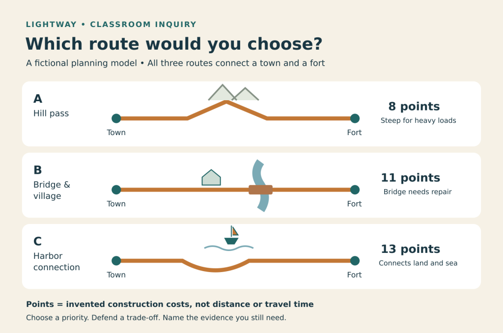
Draw or project the diagram below. It is an invented planning problem, not a map of the Roman Empire. The points are invented construction costs, not Roman money, distance, or travel time. Their purpose is to make students explain competing priorities.
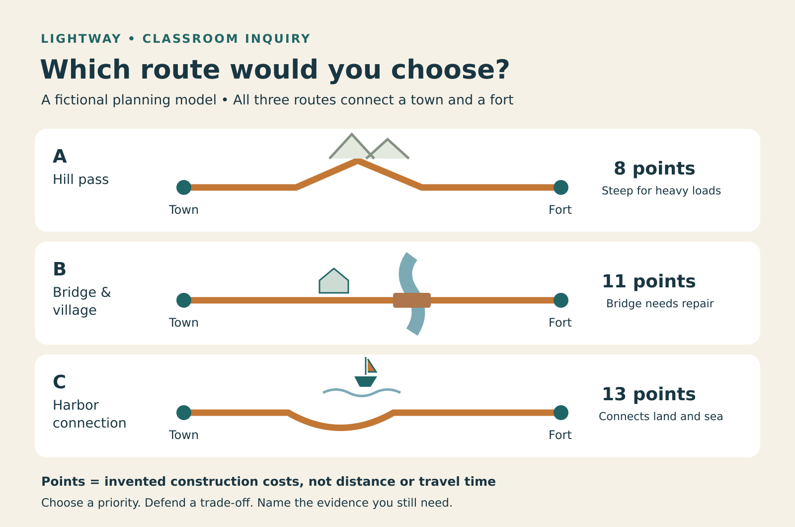
Student task: Recommend one route to a planning team. Choose a priority: moving heavy supplies, connecting markets, or limiting construction cost. Use two details from the model and connect your explanation to one of the historical sources. Then explain who could benefit, who could face a burden or risk, and what additional information you would need.
There is no single correct route. A strong answer makes its priority visible and addresses a disadvantage. Students should not claim that their model proves where Romans built an actual road.
3. Run the 45-minute lesson
- Notice the tension · 5 minutes. Write “A new road reaches your town.” Ask students for one opportunity and one concern. Accept tentative ideas; tell students they will test them against evidence.
- Model evidence and inference · 8 minutes. Read Evidence A together. Model: “The account links the first road to military expansion. I infer that better movement could support control.” Underline the source detail and circle the inference.
- Investigate in pairs · 10 minutes. Assign Evidence B and C. Each pair writes one observation, one inference, and one unanswered question. If reading is difficult, read the source description aloud before partners respond.
- Choose and defend a route · 12 minutes. Give groups the three route cards. Each group selects a priority, chooses a route, and prepares a four-sentence recommendation. Assign a reader, evidence checker, and reporter, combining roles for pairs.
- Compare the reasoning · 7 minutes. Hear two different recommendations. Ask, “Did the groups disagree about the evidence, or did they choose different priorities?” Invite each group to revise one sentence.
- Exit ticket · 3 minutes. “Explain how a road could support both exchange and control. Use one source detail and name one limit of your evidence.”
4. Make the writing doable
Offer this frame: “Our group recommends route __ because our priority is __. The model shows __, although __ is a disadvantage. Source __ suggests that roads could __. We still need to know __ before deciding whether this plan benefits the local community.”
For a lighter reading load, display one source at a time, define the four vocabulary words aloud, and allow an oral response before writing. For an extension, ask students to compare the date of the Via Appia’s beginning with the third-century CE milestone. What might be misleading about treating the whole Roman road network as one project built at one moment?
Quick assessment: Check for a specific detail, a logical explanation, a second perspective, and a genuine limit or question. A route choice by itself is not evidence of historical understanding.
Show a possible exit-ticket response
The Via Appia account connects the road’s early purpose with military expansion and its later use with trade. A road could therefore help merchants move goods while also helping a state move soldiers. These sources do not tell us whether every community along a road welcomed Roman rule.
Check for understanding
Have students answer before opening the explanations.
1. Does an emperor’s name on a milestone prove travelers supported him?
No. It is evidence that imperial names were displayed. Travelers’ beliefs require additional evidence, such as accounts from particular people or communities.
2. Can the lowest-cost route in this model be called the fastest Roman route?
No. The points represent invented construction costs. The model supplies no measured travel times, and it is not a reconstruction of a real Roman route.
3. Why include a port in a lesson about roads?
The Richborough example shows that a road could connect with sea travel. Studying the connection helps students explain a transport network rather than treating land routes in isolation.
Teacher FAQ
Can I teach this in 25 minutes?
Yes. Use 5 minutes for the opening question, 8 for the milestone and its caption, 8 for the route choice, and 4 for an exit response. Save the other evidence stops for the next lesson.
Do students need individual devices?
No. Project the source pages and diagram, or draw the model on the board. Students can record their observations and recommendations on plain paper. Review the source providers’ terms before reproducing their images.
Should students memorize a road-building formula?
This lesson assesses historical reasoning, not a universal construction recipe. Avoid presenting every Roman road as identical. Keep the focus on the evidence available for particular places, periods, and uses.
Connect the activity to your Rome unit
This inquiry can introduce a wider discussion of Roman power, cities, and later connections. Explore Lightway’s Rome & Christendom lesson series to see the sequence and linked resource previews. Choose materials that fit your students and curriculum.
Historical source pages checked October 5, 2026. Activity structure, prompts, model routes, and diagram are original classroom materials by Lightway Teaching Resources.
